Earth's Energy at Night
Sunday, July 9th, 2017 11:14 pmToday's Astronomy Picture of the Day is a nice Earth at Night image from 2012. Click to see the hi-res version:

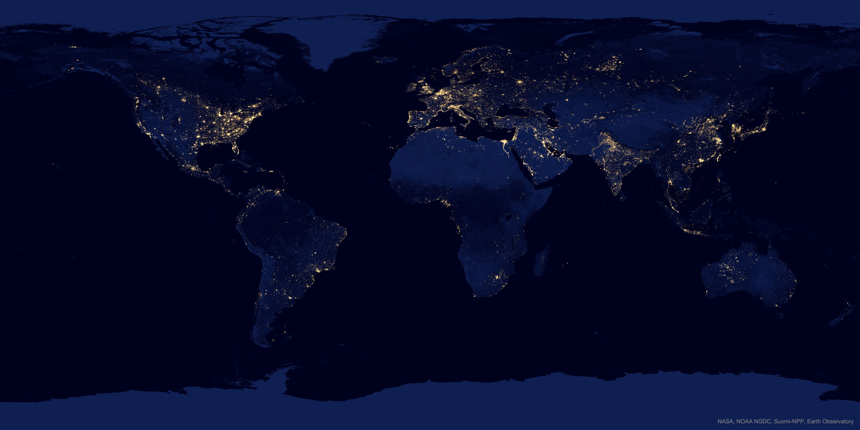
The position of North Korea are very prominence, due to the distinct lack of lights compared to their neighbors
Myanmar shows significantly more light than North Korea, suggesting that development there is expanding
The Empty Quarter (of Arabia) really is empty
Moscow is a lovely 8-pointed star as people have filled in along the arterial highways
Metro Bangkok (famous for having the worst traffic in the world) is larger than I'd expected
The whole Straight of Malaca is lit up. I'm not sure if that's development on the shore or cargo ships.
The brightness of the lower Nile and its delta are always striking. I suspect this may be in part due to the presence of the Aswan dams generating power, not just the population density
Israel is somewhat brighter than its neighbors, though western Jordan is fairly solid
Europe has several areas that are basically solid light, with big cities only slightly brighter while America has very prominent metropolises with more subdued dots (in the east) and open space (in the west)
Speaking of the American east–west divide, there's almost a vertical line from Winnipeg do the mouth of the Rio Grande separating the "plenty of people" part of the country from the "a few metropolitan oases until you get to the Pacific coast" part of the country
Though a little less distinct, there's a ring around much of the Tibetan Plateau
The Caspian coast of Iran is a more populated area than many folks realize
Many folks would also be surprised by the brightness of Java, though as the most populous island in the world it should be expected
Taiwan has an interesting western crescent of light
Puerto Rico is almost as bright as the Florida coast
McMurdo Station doesn't make enough light to show up, but Antarctica has a high albedo, even at night
Not only are there very few lights in the Congo rainforest, it also reflects less moonlight than the deserts to its north, south, and east. The Amazon has a similar effect.
If you're wondering what's up with West Australia, the images were taken when bush fires were burning
I had an Earth at Night poster in my dorm room nearly 20 years ago. Some notable areas that stand out now:
- Large oil and gas installations are very prominent, and were fairly absent in the late '90s version of the map. There are lots of very bright lights in…
- The middle of the Persian Gulf
- The Bakken formation in North Dakota and the Alberta tar sands
- Bazhenov formation near the Ob river in Siberia
- Off the coast of the Niger and Congo deltas
- To a lesser extent, the coasts of northern Alaska, Louisianna, and Venezuela, and the middle of the Caspian Sea
- I'm not sure what's up with the bright area the shape of Vermont to the south of Korea and west of Japan. It looks further north than the maps I see when I search [East China Sea oil fields]. Maybe it, the dots between Hainan and Vietnam, like the lines between Argentina and the Falkland Islands, signals night fishing
- The area around Kyrgyzstan and Uzbekistan is brighter than I expected, too